From Weighlock to Skatepark
- Geoffrey Zeiner
Reposted with permission from the Gonechester blog
This is the story of one small area’s evolution. A busy riverfront of the Genesee, where river met canal met mill race. Eventually added to the mix subways, and railroads, and highways… It was a busy and ever-evolving area, suffice to say.
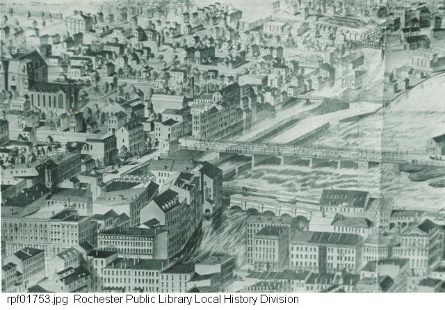
1868
[https://catalogplus.libraryweb.org/?section=resource&resourceid=1116602870]
The above lithograph shows the aqueduct and the Court Street bridge. The weighlock and its associated change-bridge are visible in the upper right quadrant.
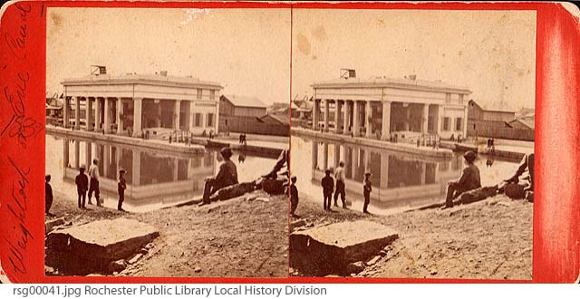
The weighlock in a stereograph from 1875.
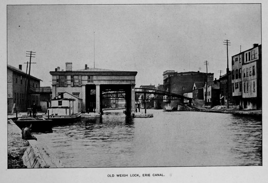
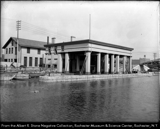
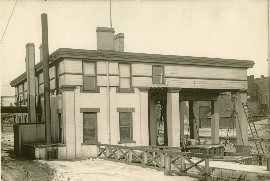
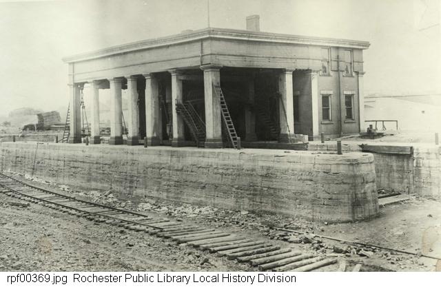
The weighlock (or weigh lock) was built in 1852. It was located on the east side of the Genesee River, just south of Court Street. Canal boats entered the covered area, inside of which a lock lowered the water until the boat rested on giant scales. There, the toll was determined by the weight of the loaded boat. This process apparently took roughly fifteen minutes.
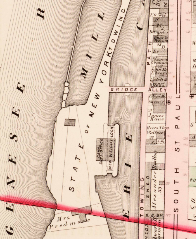
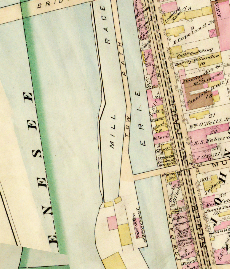
1875 Atlas
[http://photo.libraryweb.org/rochimag/rpm/rpm00/rpm00133.jpg]
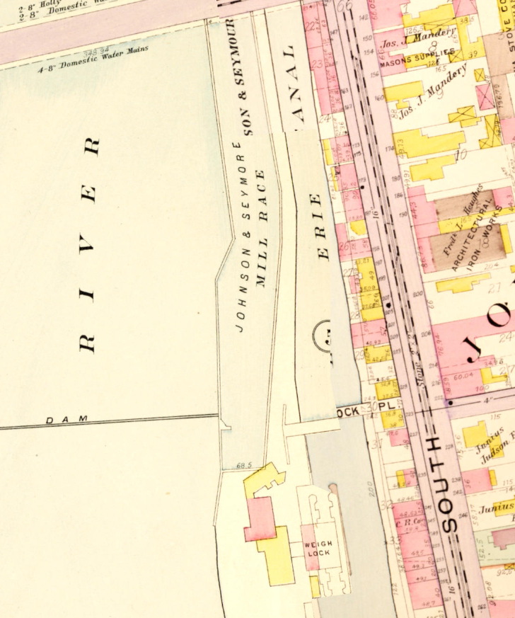
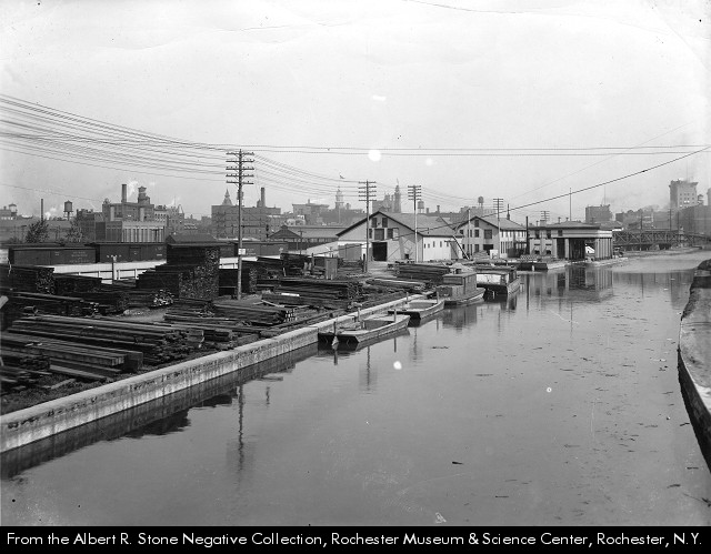
The Erie Canal, Johnson & Seymour Mill Race, and Genesee River flowed alongside each other for this small section; to the north of the Court Street Bridge the aqueduct carried the canal over the river to the west side of the city.
Canal boats and barges would be towed along the canal by mules walking upon the parallel towpath. The bridge was available for the mules to cross over to the other side when the towpath switched sides.
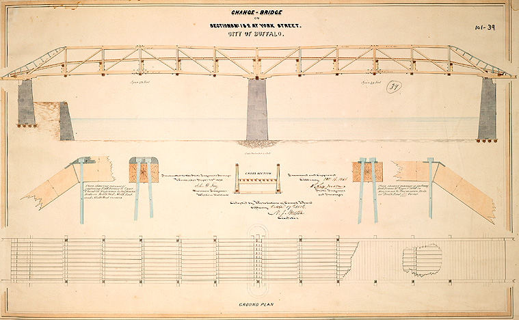
“A Change Bridge is designed to allow horses or mules to cross the canal when the towpath crosses from one side to the other. The Erie Canal towpath generally ran on only one side of the canal; sometimes on the north, other times on the south, as geography warranted. When the towpath shifted from one side of the canal to the other, it was necessary for the horses or mules to change sides as well. A change bridge was designed to make this possible without unhitching and re-hitching the draft animals. A mule pulling a boat towards the viewer would pass under the bridge on the towpath at the left, circle around to the left and up onto the bridge. It would cross the bridge from left to right, walk down the bank on the right (not included in this drawing), and continue towards us on the right.”
[https://www.eriecanal.org/UnionCollege/The_Bridge2-add.html]
“This bridge was built in Buffalo. It is a double-span truss bridge, built of wood. It needed a central pier, an unusual feature for a change bridge. The piers on each side are footed with wood, but the central pier rests on the gravel of the canal-bed.
The trussed sides, which support the weight of the roadway, are braced with sets of two converging iron rods. The bridge features a high roadway that bisects the truss providing greater stability to the structure. It also features railings designed to help the towrope slide easily over, without snagging. This bridge was also designed with special ironwork to make it easy for the rope to slide off each end. The drawings on the left and right in the middle show how this metal work is attached to the woodwork. On the right, the nut and bolt can stick out, but on the left, the nut and bolt are arranged so that the rope can pass smoothly over the top because the rope only slides over the railing on that side of the bridge.”
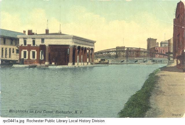
A colorized postcard of the weighlock from an unspecified time. The view is to the north.
1888 Plat Map
[http://photo.libraryweb.org/rochimag/rpm/rpm00/rpm00133.jpg]
By this point the weighlock and associated structures were beginning to look a bit shambolic, worse for wear, you know the sort of thing. It was in need of a good fixing up. So around 1896 it got a good sprucing, with a coat of white lead paint and some interior frescoes.
Boy, would I love to see those frescoes.
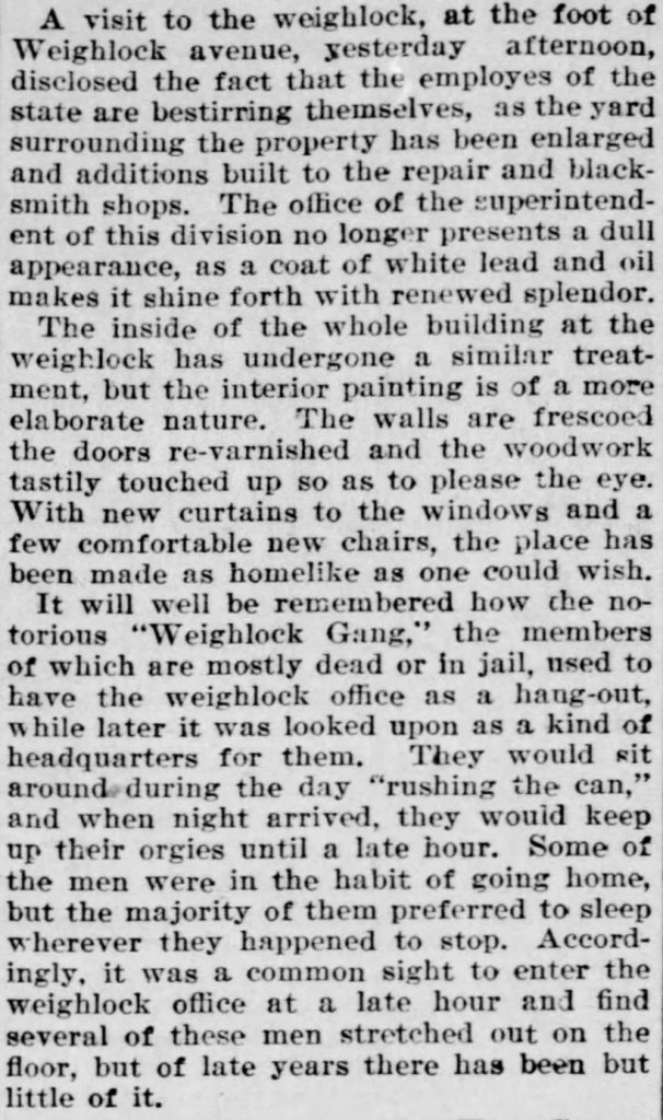
04 Jun 1896, Thu
[https://www.newspapers.com/clip/118453417/a-visit-to-the-weighlock/]
Yes, you read that correctly: the Erie Canal weighlock at the end of the 19th century was plagued by a band of toughs known as the Weighlock Gang. And these weren’t kids, either, but thieving drunken young adult men, some of whom had wives at home they would torment and abuse.
Also I dearly hope “orgies” has a slightly different connotation in this article than that which I’m accustomed to.
Let’s rewind a few years to 1890 and find an article about these notorious weighlock toughs:
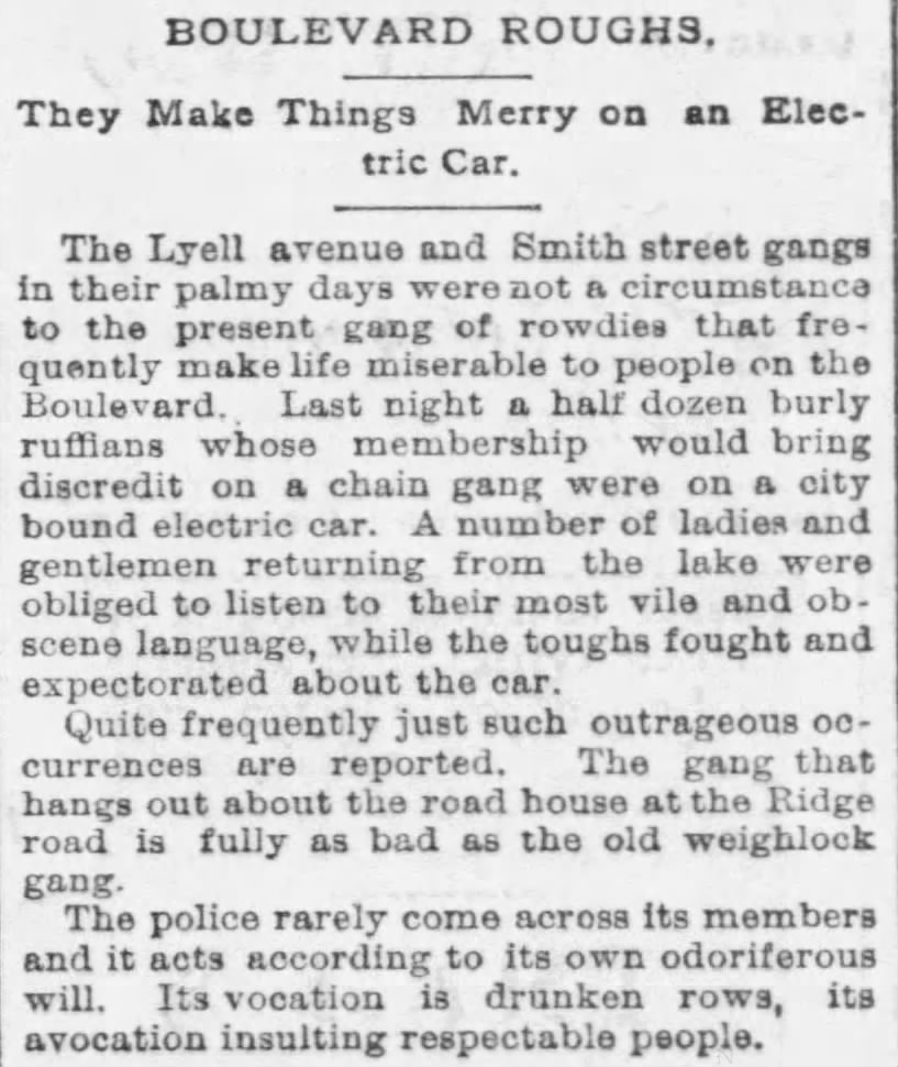
17 Jul 1890, Thu
[https://www.newspapers.com/clip/118454041/boulevard-roughs/]
By the mid-to-late 1890’s they seemed to be aging out and losing steam, if they hadn’t died on the streets or lucked upon a lengthy prison sentence. But now and again they’d turn up like a bad hay penny:
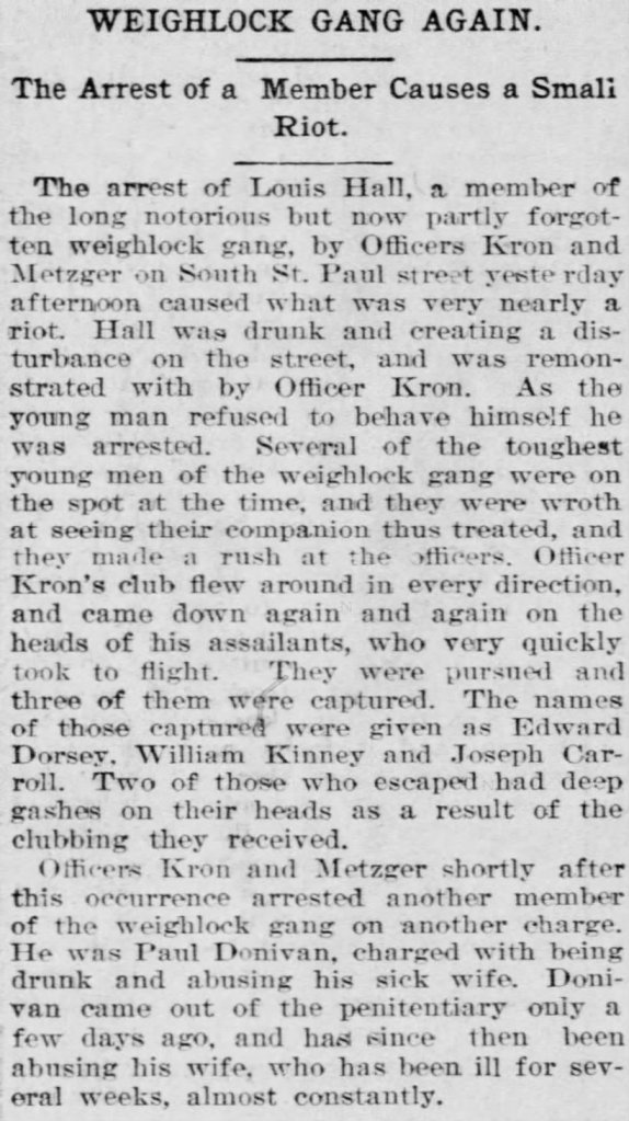
10 Jun 1894, Sun
[https://www.newspapers.com/clip/118453255/weighlock-gang-again/]
In fact, a majority of the newspaper articles I turned up for a search on “weighlock” [discounting tables of tolls] were regarding the Weighlock Gang, who apparently had an outsize presence in the media of the day.
Of course, not everyone had to be a gangster hoodlum to be an asshole. Sometimes you could just be a garden-variety drunken asshole:
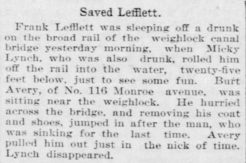
08 Sep 1894, Sat
[https://www.newspapers.com/clip/118456105/pushing-drunk-from-weighlock-bridge/]
There’s “drunk” and then there’s “manslaughter-by-drowning drunk”. Don’t be a Micky Lynch: never get manslaughter drunk. And while you’re at it, avoid “sleeping-on-a-bridge-rail drunk” as well.
23 May 1896, Sat
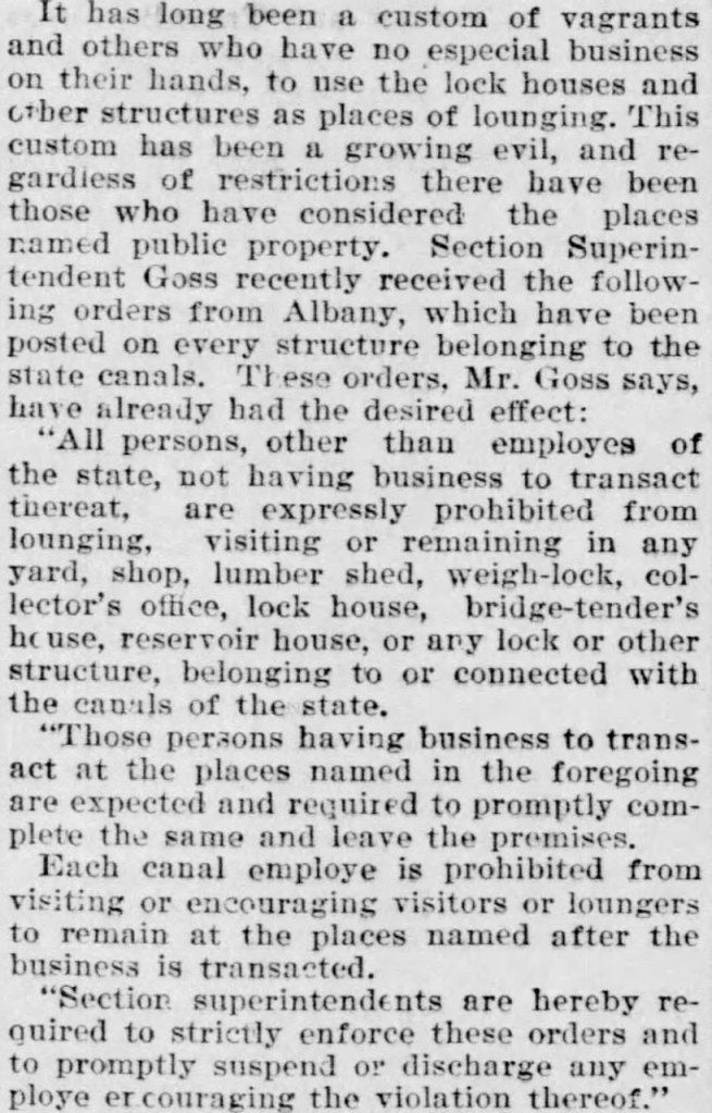
[https://www.newspapers.com/clip/118522927/vagrants-at-the-weighlock/]
I appreciate the weighlock as much as anyone, but I’m surprised it made such an attractive nuisance to the loiterers of the city. Was it the view? The opportunity to hob-knob with canalmen? The beautiful frescoes?
Whatever it was, it was frowned upon. Get these loafers out of here! demanded the State of New York.
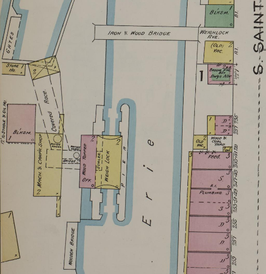
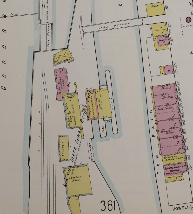
1892 Sanborn
[https://www.loc.gov/resource/g3804rm.g3804rm_g06217189202/?sp=28]
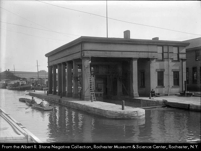
This shows a bit of the structural details of the weighlock: the iron & wood bridge across the canal; the frame weigh lock structure between the piers; the scales; the wood-topped brick offices of the weighlock superintendent; and other buildings related to the operation of the weighlock, such as a blacksmith shop and carpentry shop. There were also a pair of waterwheels in a covered race beneath the weighlock complex.
1896
[https://libraryweb.org/~digitized/books/United_Typothetae_of_America.pdf] (p.53)
One can see the small bridge between the weighlock and the machining and carpentry shop to its west in the photograph above. The bridge is also nicely visible.
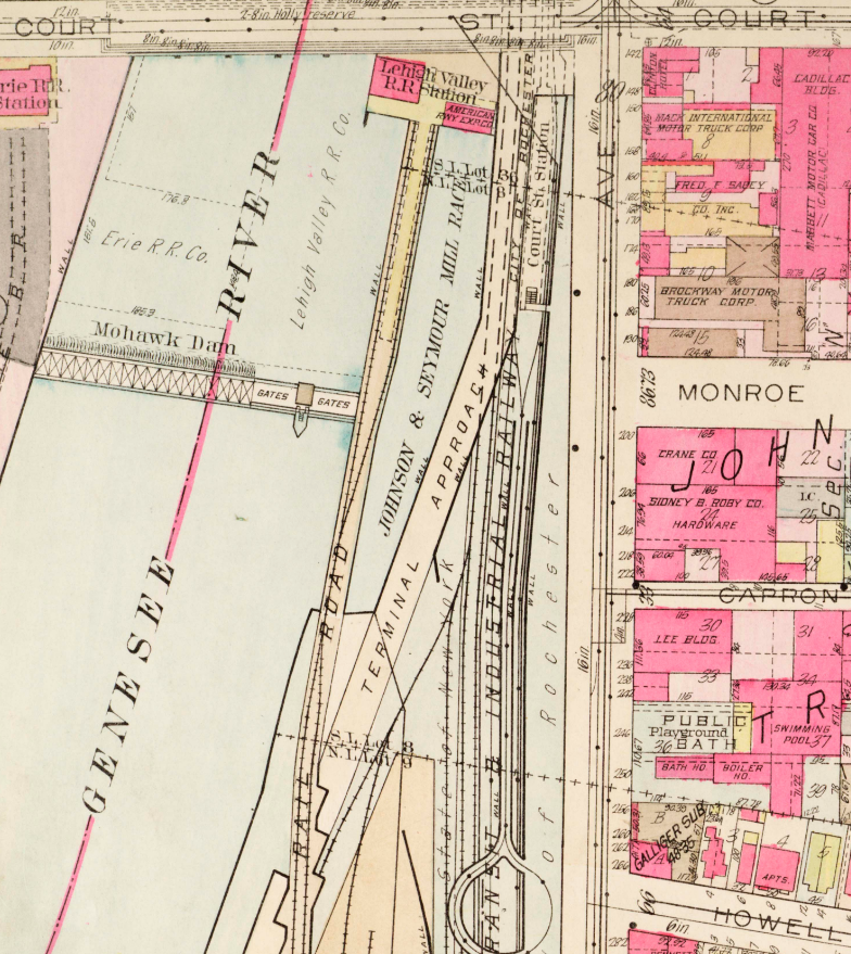
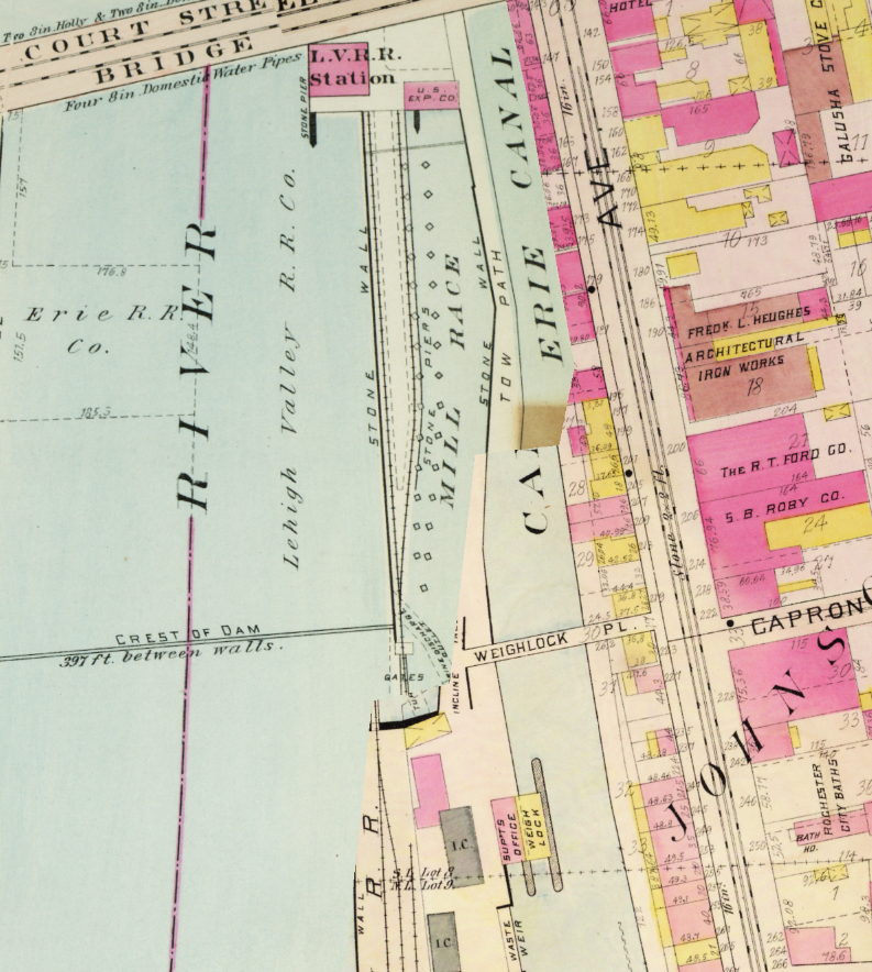
1900 Plat Map
[http://photo.libraryweb.org/rochimag/rpm/rpm00/rpm00168.jpg]
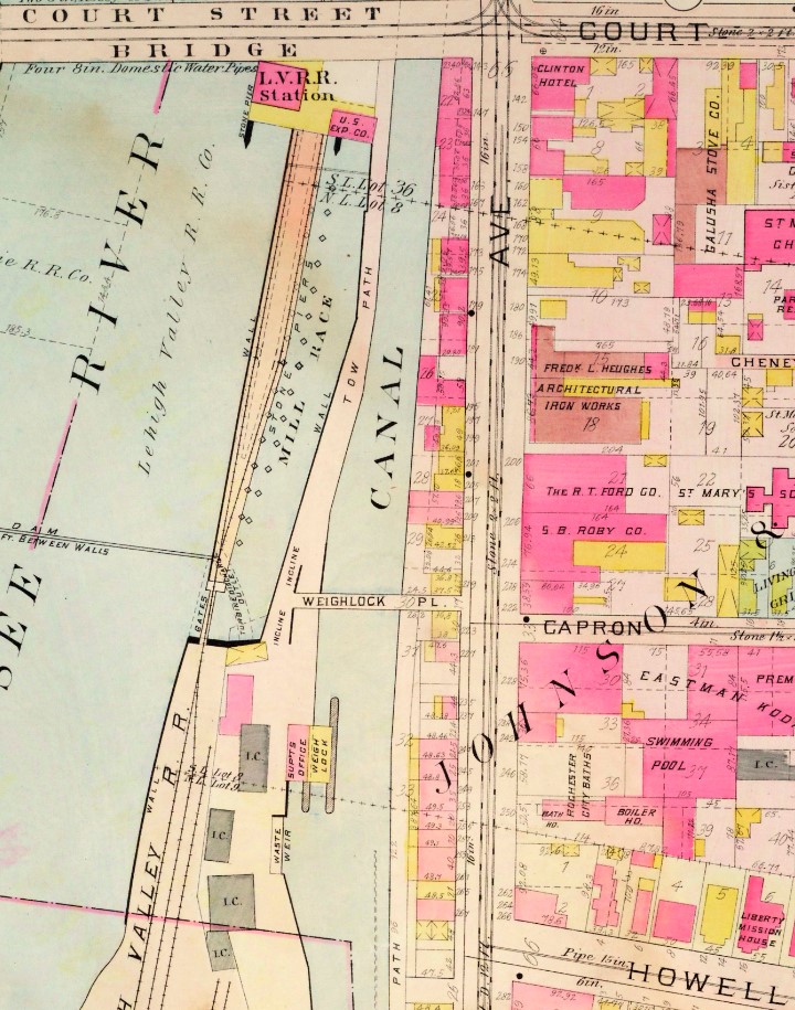
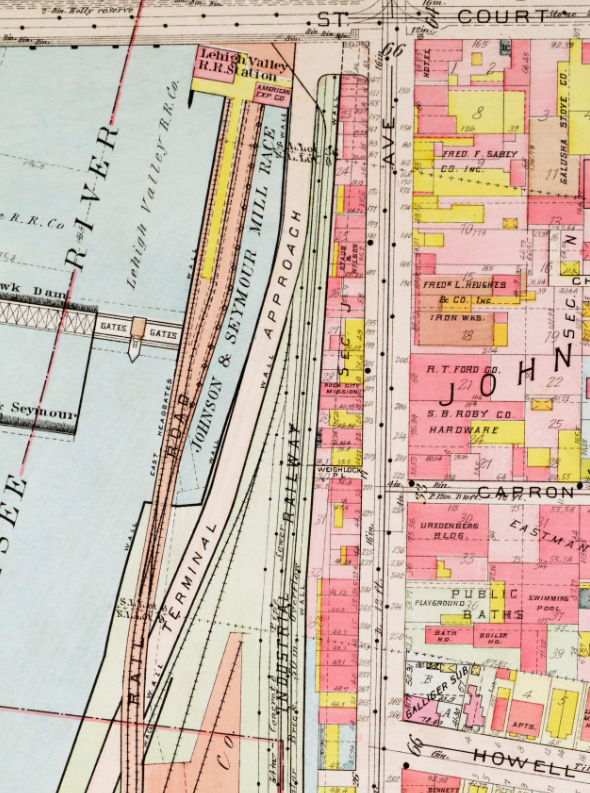
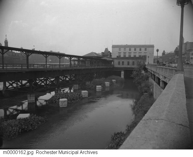
In 1905, the LeHigh Valley Railroad was routed through the area; the train station was constructed between the river and the mill race, immediately south of the Court Street Bridge.
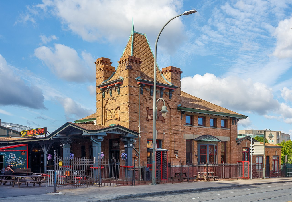
Former LeHigh Valley Railroad Station as it appears today, the current home of Dinosaur Bar-B-Que.
1906
[https://www.loc.gov/resource/pan.6a19819/]
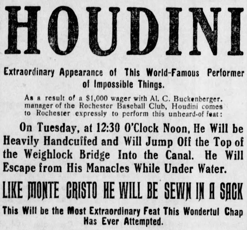
Sun, May 5, 1907
[https://www.newspapers.com/article/democrat-and-chronicle-houdini/127037996/]
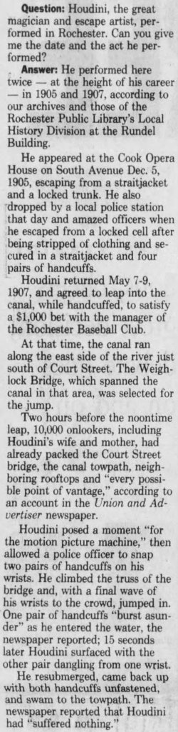
Wed, Oct 4, 1995
[https://www.newspapers.com/article/democrat-and-chronicle-houdini/127038683/]
The weighlock bridge was also noteworthy for being the site of Houdini’s first filmed stunt: leaping handcuffed from the bridge into the Erie Canal.
1910
[http://photo.libraryweb.org/rochimag/rpm/rpm00/rpm00284.jpg]
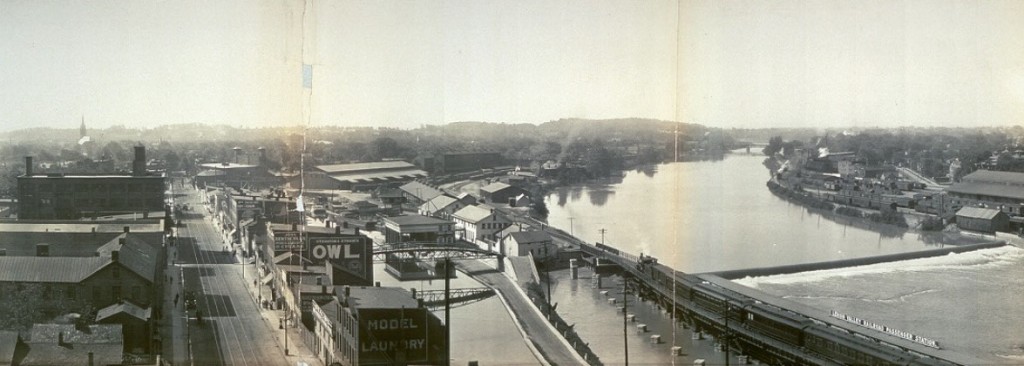
In the map above one can see the LeHigh Valley railroad station on the southern side of the Court Street bridge and the train tracks along the wall dividing the Johnson & Seymour mill race from the Genesee River.
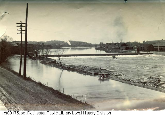
The Genesee River and the Johnson and Seymour Dam and Raceway, to the south of the Court Street Bridge area. The Erie Canal towpath is to the left, to the right the millrace and the river. The view is to the south.
1912
[https://catalogplus.libraryweb.org/?section=resource&resourceid=1115899382]
A view north towards the weighlock and Weighlock Place bridge
1911
[https://catalogplus.libraryweb.org/?section=resource&resourceid=1116689916]
North towards the weighlock.
1910
[https://catalogplus.libraryweb.org/?section=resource&resourceid=1116708071]
The Weighlock at South Street and the western end of the Weighlock Place bridge.
1911
[https://catalogplus.libraryweb.org/?section=resource&resourceid=1116866675]
The weighlock, looking north, 1910
[https://tourblend.stqry.app/en/tour/15390/item/158534]
Boats in the weighlock, looking south from the immediate north.
1915
[https://catalogplus.libraryweb.org/?section=resource&resourceid=1115929548]
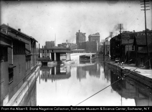
A view south towards the weighlock from Court Street Bridge.
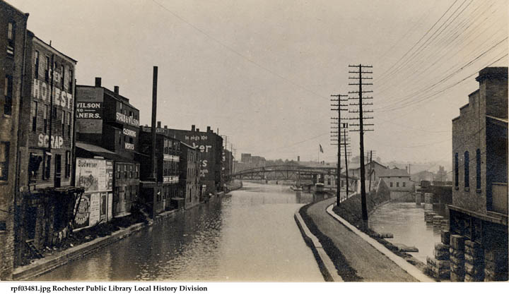
“The image shows the Erie Canal and the feeder canal at South Avenue. This also shows the backs of the buildings from South Avenue between Court Street and Weighlock Place, including the Staub & Wilson dry cleaning establishment.”
1911
[https://catalogplus.libraryweb.org/?section=resource&resourceid=1430521477]
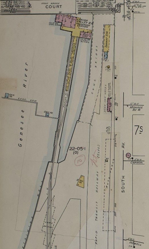
1912 Sanborn Map
[https://www.loc.gov/resource/g3804rm.g3804rm_g06217191204/?sp=10&r=-0.173,0.675,0.942,0.579,0]
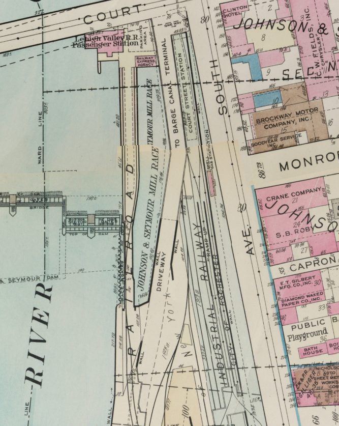
1918 Plat Map
[http://photo.libraryweb.org/rochimag/rpm/rpm00/rpm00345.jpg]
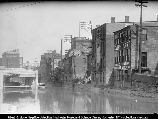
“A view of the Erie Canal and the rear of buildings on South Avenue looking from the Court Street Bridge. The canal weighlock is pictured to the left with the roof of the Granite Building visible just over its top. Identifiable businesses to the right are the Car-Hart photo finishing shop, Staub & Wilson and The Homestead Hotel for Men.”
1920
[https://cdm16694.contentdm.oclc.org/digital/collection/p15109coll11/id/151]
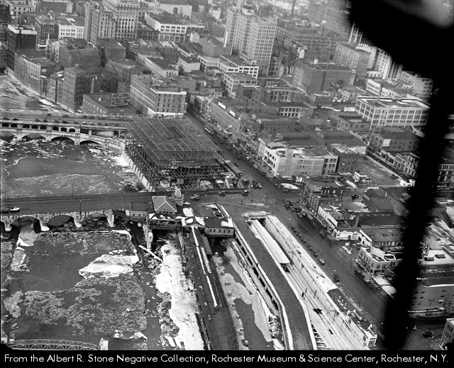
“Tracks for the Rochester subway are being laid near the Erie Canal Weighlock on the east side of the river just south of Court Street. The weighlock was built in 1852. Canal boats came inside the building for their tolls to be determined based on their weights.“
1922
[https://catalogplus.libraryweb.org/?section=resource&resourceid=1115911820]
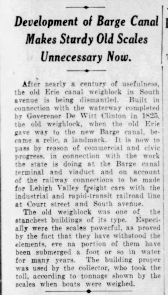
With the development of the Barge Canal and the construction of the subway, the weighlock was defunct.
17 Sep 1922, Sun
[https://www.newspapers.com/clip/109732226/rccn-lweighlock2/]
Come 1922, the weighlock was slated to be dismantled.
The razing of numerous weighlocks along the retired Erie Canal took place around this time, as Barge canal infrastructure replaced outdated Erie Canal infrastructure. Weighing and fees were no longer part of everyday canal operations, meaning these noble edifices had few practical reasons to exist.
Syracuse, New York preserved its weighlock and transformed it into an Erie Canal museum:
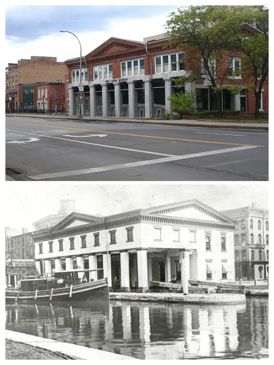
Top: the modern structure on Erie Boulevard
Bottom: the operating weighlock in 1903.
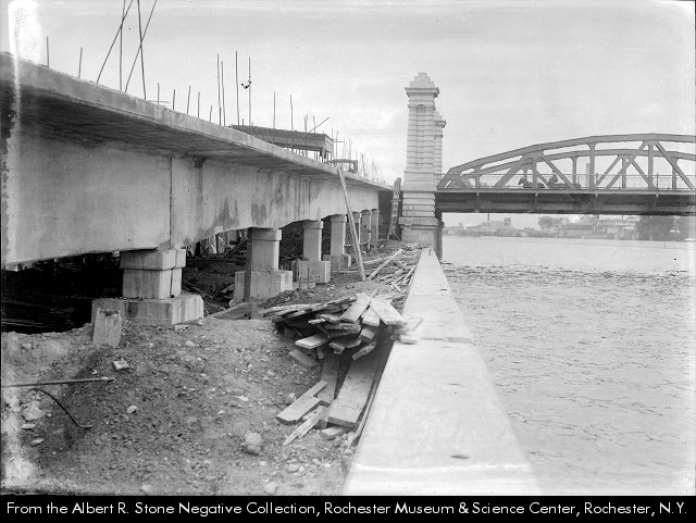
“The Erie Canal just south of the Court Street Bridge. Photo shows the construction of the proposed approach to the Barge Canal harbor. Lehigh Valley Station is visible to the right.”
c.1919
[https://catalogplus.libraryweb.org/?section=resource&resourceid=1116043482]
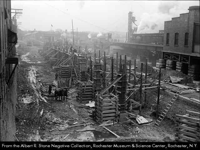
One can see the weighlock dimly amidst the fog in the background of the above shot from 1919, during the construction of an approach ramp to the new Barge Canal’s terminal.
Nearly-complete construction of the approach ramp to the Barge Canal Terminal, c.1922.
[https://catalogplus.libraryweb.org/?section=resource&resourceid=1116176353]
1926 Plat Map
[http://photo.libraryweb.org/rochimag/rpm/rpm00/rpm00082.jpg]
The weighlock is vanished in the 1926 plat map, above. History continues apace, bereft of one of the canal’s oldest structures.
This map also was the last appearance of the old Mohawk Dam, which was demolished in 1929.
1935
[http://photo.libraryweb.org/rochimag/rpm/rpm00/rpm00464.jpg]
c.1934-1935
[https://catalogplus.libraryweb.org/?section=resource&resourceid=1116891499]
The above is an aerial showing construction of the Rundel Library on pilings over the Johnson & Seymour mill race, 1934-1936. LeHigh Valley Railroad Station is on the other side of the Court Street Bridge from the library construction.
1950 Plat Map
[https://www.loc.gov/resource/g3804rm.g3804rm_g06217195001S/?sp=60&r=-0.333,0.167,1.114,0.684,0]
It’s crazy how much is going on in this small section of riverside by this point.
Stone piers in the Johnson & Seymour Mill Race next to the LVRR tracks, 1951
[https://catalogplus.libraryweb.org/?section=resource&resourceid=1115929637]
1950’s
Above, the area in the late 1950’s, shortly after the 1953-1955 construction of the Troup-Howell Bridge across the Genesee River.
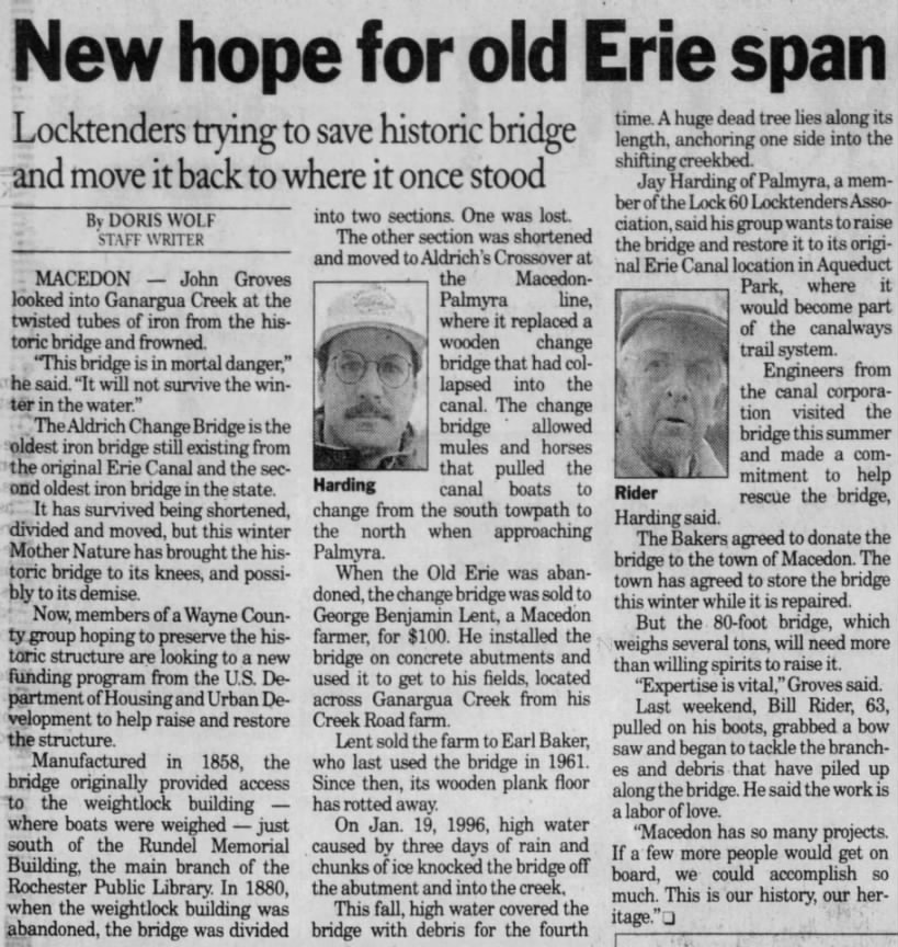
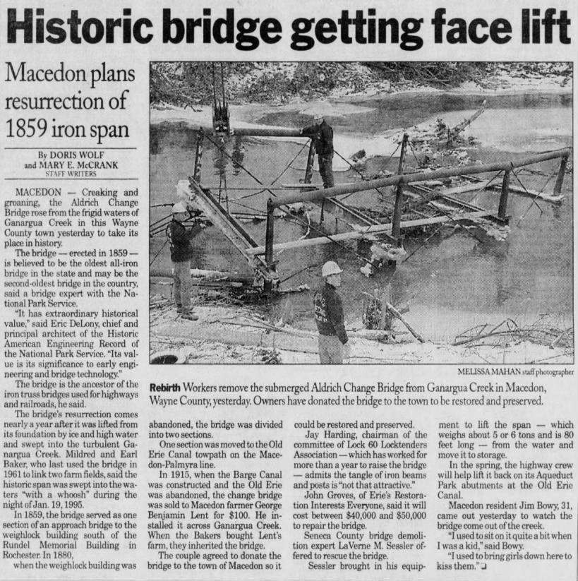
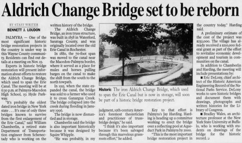
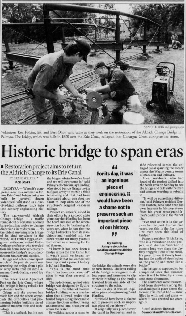
The cast iron change-bridge [designed by Squire Whipple] which led from Weighlock Place to the weighlock proper was sold off in two sections, one of which would eventually end up bridging a creek in Macedon. After collapsing in 1996, it was restored and installed into the Palmyra-Macedon Aqueduct Park in 2004.
Tue, Nov 26, 1996
[https://www.newspapers.com/article/democrat-and-chronicle-change-bridge/127033086/]
12 Jan 1997, Sun
[https://www.newspapers.com/clip/118471036/piece-of-change-bridge/]
Sun, Nov 8, 1998
[https://www.newspapers.com/article/democrat-and-chronicle-aldrich-change-br/127035529/]
Mon, Jul 1, 2002
[https://www.newspapers.com/article/democrat-and-chronicle-aldrich-change-br/127036865/]
Mon, Jul 26, 2004
[https://www.newspapers.com/article/democrat-and-chronicle-adlrich-change-br/127035984/]
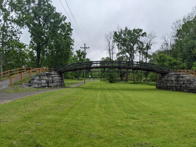
The Aldrich Change Bridge as it appears in the Pal-Mac Aqueduct Park
Photo from Google Maps, taken by Robert Esplin
I’m not sure where the idea of an 1880 abandonment of the weighlock mentioned in the above articles came from. It doesn’t seem to be corroborated by any sources, much less the many sources in this post which suggest the weighlock was in use until the construction of the Barge Canal circa 1915. However, multiple articles claim that the bridge was divided and removed in 1880; therefore I can only suppose the bridge was removed and replaced with a different one at that date.
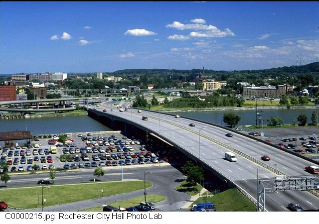
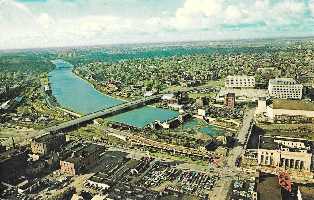
The Troup-Howell bridge in 1990.
[https://catalogplus.libraryweb.org/?section=resource&resourceid=1115918974]
Above, the Troup-Howell Bridge crossing the Genesee, as viewed from the west. The spiral off-ramp is visible at left, which now winds around the skate park.
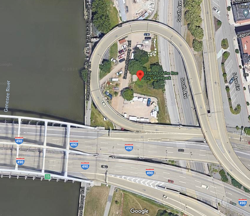
The satellite image of this area seems to be lagging, the skatepark appears to still be under construction in the latest shot.
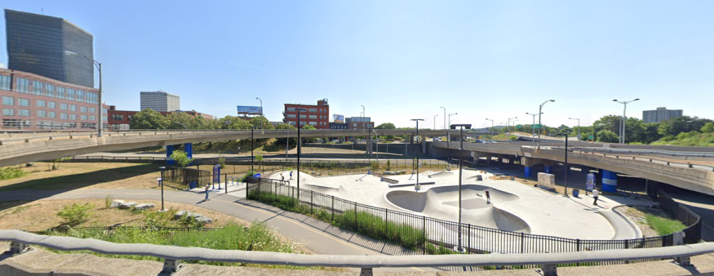
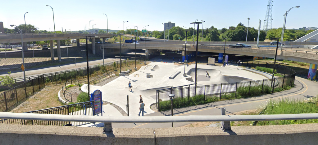
The Friends of the ROC skate park as seen from the 490 off-ramp.
A fly-through animation of the skate park: [https://youtu.be/owdMl–gtuA]
The following photographs were taken by me on February 11th, 2023:
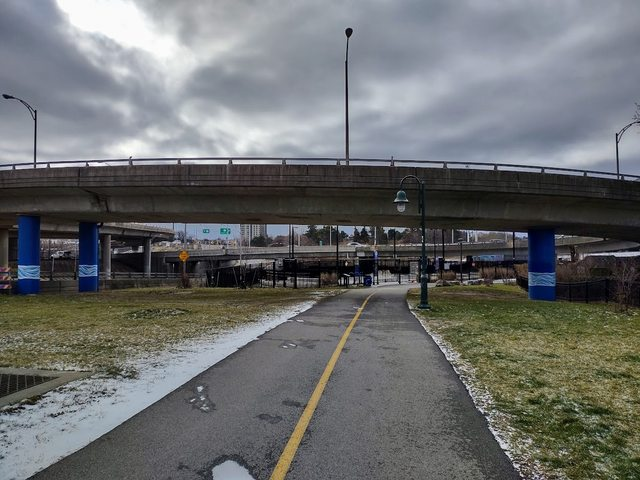
Approach to the skatepark from the north along the Genesee Riverway Trail. The off-ramp from 490 can be seen in the foreground. And in the background!
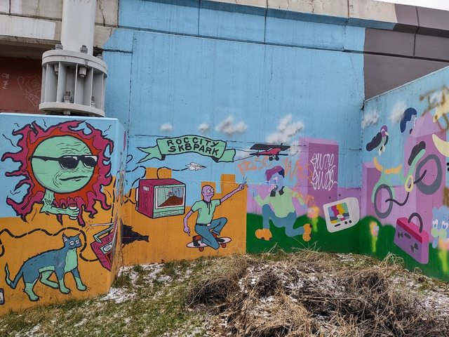
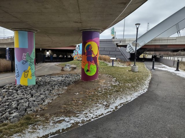
Mural on the side of the off-ramp.
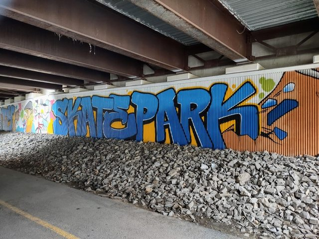
Mural under the off-ramp.
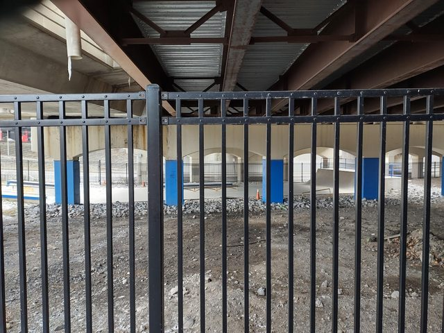
Ramp under the off-ramp. Heh. Ramps.
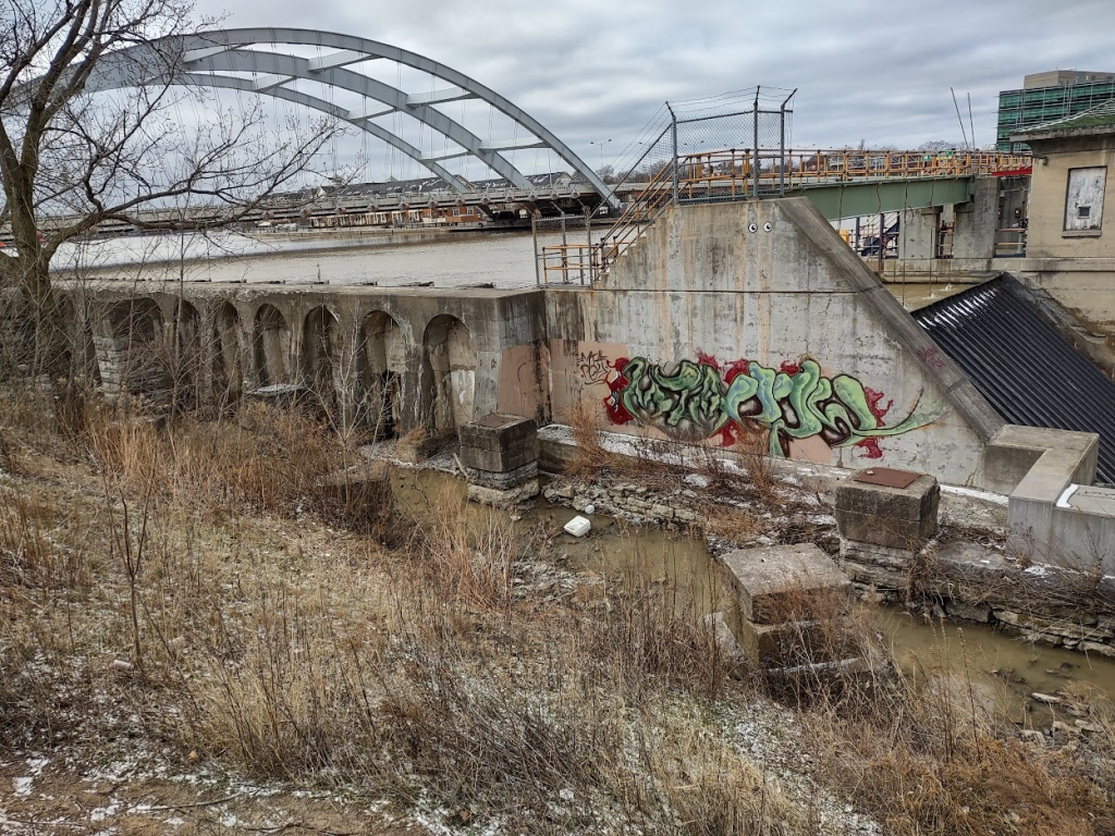
A little bit of the Court Street Dam, and some old stone piers.
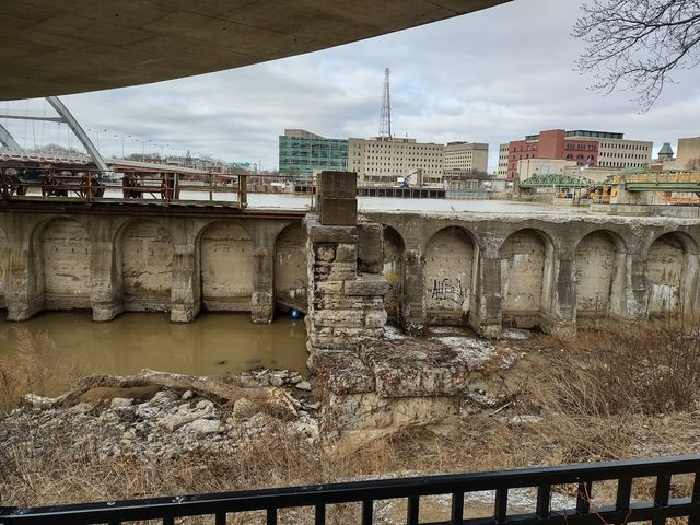
Some stonework pilings from either the railroad or the Barge Canal Terminal approach; and a concrete wall dividing the Erie Canal from the Johnson & Seymour Mill Race.
Spot the rubber ball.
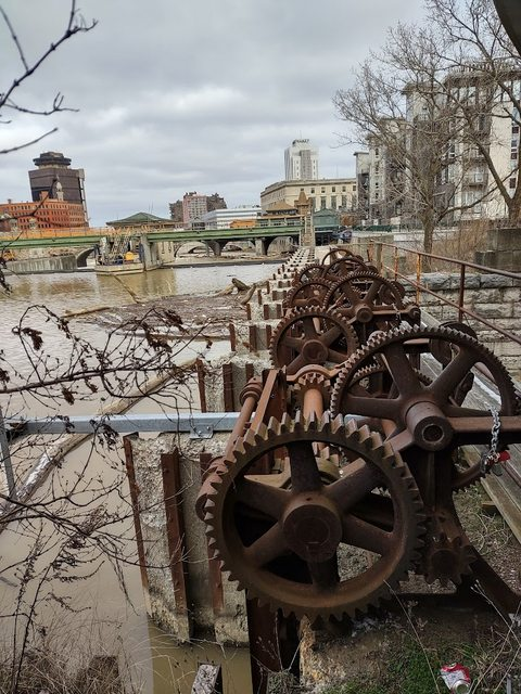
Some gears, part of the control mechanism for the mill race flow gates, and the remnants of reinforced concrete pilings from the railroad.
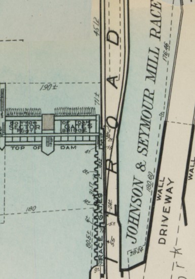
The mill race gates on the 1935 Plat Map.
Some painted off-ramp pillars, and the launching point for the eastern end of the Frederick Douglass-Susan B. Anthony Memorial Bridge.
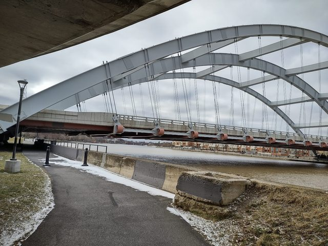
The Freddy-Sue.
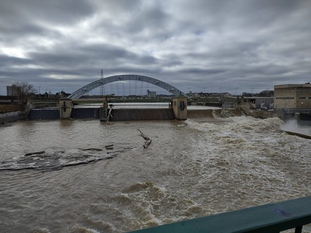
The Freddy-Sue behind the Court Street Dam, from the Court Street Bridge.
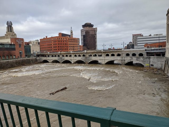
The Broad Street Bridge, formerly the aqueduct, from the Court Street Bridge.
Also visible, from left to right:
The Times Square Building
The Mercury Statue
The First Federal Plaza Building
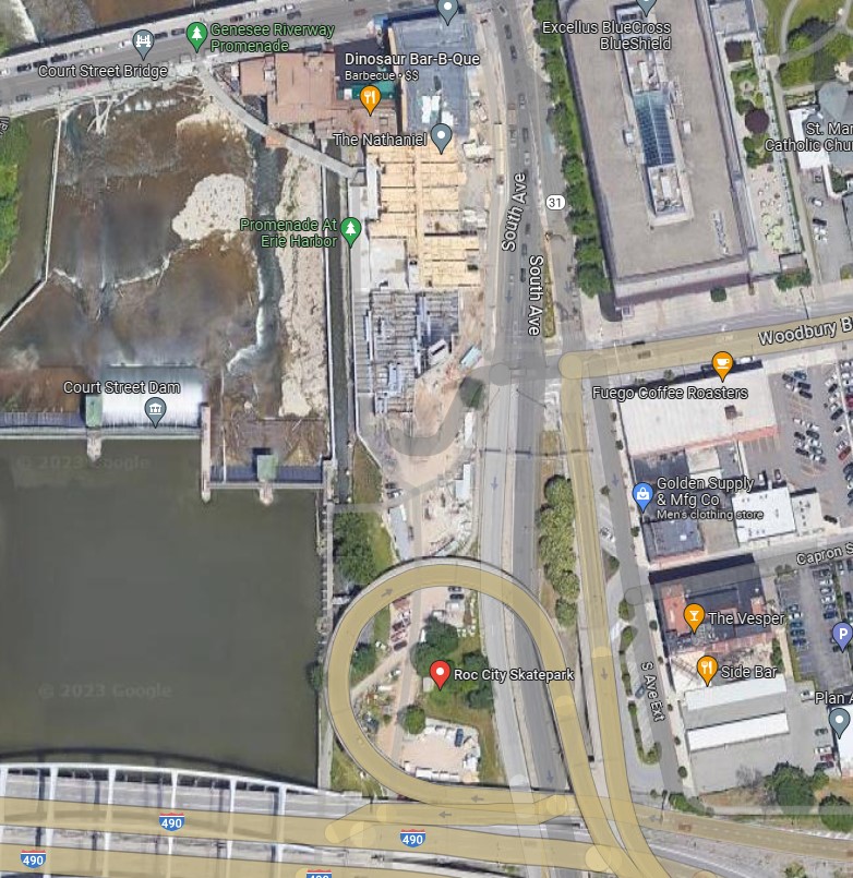
A comparative image between 1910 Plat map and today. Please forgive me, as this isn’t perfectly lined up; I tried my best though.
As you can see, much has changed. What once served as the beating heart of the city’s Erie lifeblood now serves as a nexus of recreational sport. One can almost imagine glancing across a century’s span to catch a glimpse of the weighlock as they’re landing the perfect ollie.
Want to publish a guest post?
Subscribe to Our Monthly Update
Enjoy our once-monthly newsletter highlighting our efforts to beautify downtown Rochester
Want to be a ROCstar?
Please consider supporting the work of Downtown ROCs with a tax-deductible gift. Every dollar directly funds awesome projects that beautify & energize our city.
Thank you for your support! 🙏🏼